Geolocate

Havelock topographic map

Click on the map to display elevation.

About this map
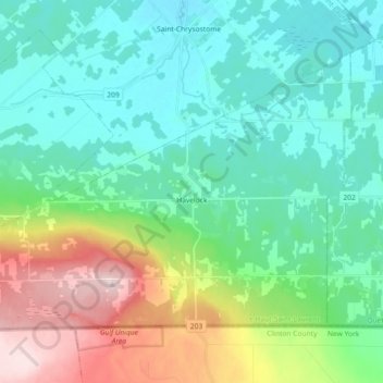
Name: Havelock topographic map, elevation, terrain.

Location: Havelock, Le Haut-Saint-Laurent, Montérégie, Quebec, J0S 2C0, Canada (45.00168 -73.86410 45.09458 -73.68276)

Average elevation: 122 m

Minimum elevation: 44 m

Maximum elevation: 343 m

Other topographic maps

Click on a map to view its topography, its elevation and its terrain.

Snye

Canada > Quebec > Le Haut-Saint-Laurent > Snye

Average elevation: 49 m

Cazaville

Canada > Quebec > Le Haut-Saint-Laurent

Average elevation: 58 m

Covey Hill

Canada > Quebec > Le Haut-Saint-Laurent > Havelock

Average elevation: 283 m

Doréa

Canada > Quebec > Le Haut-Saint-Laurent > Franklin

Average elevation: 242 m

Gear up for your next adventure:

🕶️Polarized Sunglasses - UV protection sunglasses for outdoors
🛰️Handheld GPS Units - Rugged GPS devices for tracking coordinates and elevation in the Australian bush
🦶Orthotic Hiking Insoles - Extra arch support for long-distance topographic treks
🧊Insulated Stainless Steel Flasks - Keep water cold for 24 hours in the heat or coffee hot in the cold
🚴Cycling Backpacks - Backpacks for cyclists

As an Amazon Associate, this site earns from qualifying purchases at no extra cost to you.