
Cashiers topographic map
Click on the map to display elevation.
Cashiers
Cashiers lies in southern Jackson County on the elevated Highlands-Cashiers Plateau, a highland setting within the southern Blue Ridge Mountains, with the village center standing at about 3,500 feet (1,067 m) above sea level. Its topography is defined by a relatively open mountain basin surrounded by higher ridges, rounded knobs, forested slopes, and deeply cut stream valleys, giving the area a compact but varied relief. Around the settlement, elevations rise toward nearby summits and ridge systems, while drainage corridors linked to the Chattooga, Horsepasture, and Tuckasegee river headwaters carve lower, wetter passages through the plateau. The overall physical character is that of a cool, rugged Appalachian upland: gently rolling in the village core, but quickly transitioning into steep wooded slopes, rocky escarpments, waterfalls, narrow hollows, and panoramic Blue Ridge terrain.
About this map
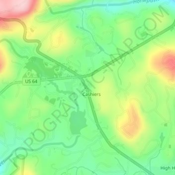
Name: Cashiers topographic map, elevation, terrain.
Location: Cashiers, Jackson County, North Carolina, United States (35.09976 -83.11297 35.12469 -83.08291)
Average elevation: 1,085 m
Minimum elevation: 1,002 m
Maximum elevation: 1,215 m