
Asse topographic map
Interactive map
Click on the map to display elevation.
About this map
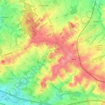
Name: Asse topographic map, elevation, terrain.
Location: Asse, Hal-Vilvorde, Brabant flamand, Flandre, Belgique (50.88453 4.13898 50.94266 4.24253)
Average elevation: 49 m
Minimum elevation: 9 m
Maximum elevation: 86 m
Other topographic maps
Click on a map to view its topography, its elevation and its terrain.
Zellik
Belgique > Brabant flamand > Hal-Vilvorde > Asse > Zellik
Zellik, Asse, Hal-Vilvorde, Brabant flamand, Flandre, Belgique
Average elevation: 56 m