
Kitwanga topographic map
Interactive map
Click on the map to display elevation.
About this map
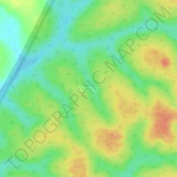
Name: Kitwanga topographic map, elevation, terrain.
Location: Kitwanga, Kiryandongo, Western Region, Uganda (1.96855 31.99110 2.00855 32.03110)
Average elevation: 1,091 m
Minimum elevation: 1,069 m
Maximum elevation: 1,117 m
Other topographic maps
Click on a map to view its topography, its elevation and its terrain.
Kitwanga
Uganda > Kiryandongo > Kitwanga
Kitwanga, Kiryandongo, Western Region, Uganda
Average elevation: 1,101 m
Murchison Falls National Park
Murchison Falls National Park, Kiryandongo, Western Region, Uganda
Average elevation: 924 m