
Make a donation
Gear up for your next adventure:
As an Amazon Associate, this site earns from qualifying purchases at no extra cost to you.
Forksville topographic map
Click on the map to display elevation.
Make a donation
Gear up for your next adventure:
As an Amazon Associate, this site earns from qualifying purchases at no extra cost to you.
About this map
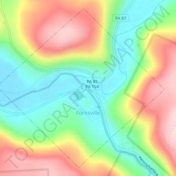
Name: Forksville topographic map, elevation, terrain.
Location: Forksville, Sullivan County, Pennsylvania, United States (41.47907 -76.62087 41.50347 -76.58650)
Average elevation: 423 m
Minimum elevation: 296 m
Maximum elevation: 586 m
Make a donation
Gear up for your next adventure:
As an Amazon Associate, this site earns from qualifying purchases at no extra cost to you.
Other topographic maps
Click on a map to view its topography, its elevation and its terrain.
Muncy Valley
United States > Pennsylvania > Sullivan County > Davidson Township
Average elevation: 378 m
Hillsgrove
United States > Pennsylvania > Sullivan County > Hillsgrove Township
Average elevation: 393 m
Make a donation
Gear up for your next adventure:
As an Amazon Associate, this site earns from qualifying purchases at no extra cost to you.