
Make a donation
Gear up for your next adventure:
As an Amazon Associate, this site earns from qualifying purchases at no extra cost to you.
Mather topographic map
Click on the map to display elevation.
Make a donation
Gear up for your next adventure:
As an Amazon Associate, this site earns from qualifying purchases at no extra cost to you.
About this map
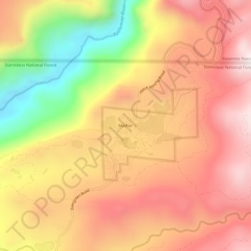
Name: Mather topographic map, elevation, terrain.
Location: Mather, Tuolumne County, California, United States (37.86215 -119.87573 37.90215 -119.83573)
Average elevation: 1,352 m
Minimum elevation: 852 m
Maximum elevation: 1,689 m
Make a donation
Gear up for your next adventure:
As an Amazon Associate, this site earns from qualifying purchases at no extra cost to you.
Other topographic maps
Click on a map to view its topography, its elevation and its terrain.
Columbia
United States > California > Tuolumne County
Columbia is located along State Route 49 just north of Sonora, at an altitude of 2,139 feet (652 m).
Average elevation: 672 m
Make a donation
Gear up for your next adventure:
As an Amazon Associate, this site earns from qualifying purchases at no extra cost to you.
Tuolumne Meadows
United States > California > Tuolumne County > Tuolumne Meadows
Average elevation: 2,668 m
Make a donation
Gear up for your next adventure:
As an Amazon Associate, this site earns from qualifying purchases at no extra cost to you.