
Make a donation
Gear up for your next adventure:
As an Amazon Associate, this site earns from qualifying purchases at no extra cost to you.
Tauru topographic map
Click on the map to display elevation.
Make a donation
Gear up for your next adventure:
As an Amazon Associate, this site earns from qualifying purchases at no extra cost to you.
Tauru
Taoru is located at 28°13′N 76°57′E / 28.22°N 76.95°E / 28.22; 76.95. It has an average elevation of 262 metres (859 feet). It is surrounded by Aravalli Range from three sides.
Make a donation
Gear up for your next adventure:
As an Amazon Associate, this site earns from qualifying purchases at no extra cost to you.
About this map
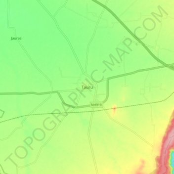
Name: Tauru topographic map, elevation, terrain.
Location: Tauru, Taoru, Nuh District, Haryana, 122105, India (28.17093 76.91064 28.25093 76.99064)
Average elevation: 267 m
Minimum elevation: 211 m
Maximum elevation: 350 m
Make a donation
Gear up for your next adventure:
As an Amazon Associate, this site earns from qualifying purchases at no extra cost to you.