
Make a donation
Gear up for your next adventure:
As an Amazon Associate, this site earns from qualifying purchases at no extra cost to you.
Rapperath topographic map
Click on the map to display elevation.
Make a donation
Gear up for your next adventure:
As an Amazon Associate, this site earns from qualifying purchases at no extra cost to you.
About this map
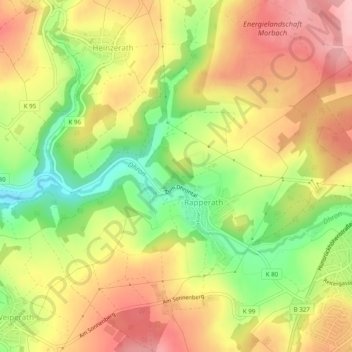
Name: Rapperath topographic map, elevation, terrain.
Average elevation: 454 m
Minimum elevation: 364 m
Maximum elevation: 529 m
Make a donation
Gear up for your next adventure:
As an Amazon Associate, this site earns from qualifying purchases at no extra cost to you.
Other topographic maps
Click on a map to view its topography, its elevation and its terrain.
Weiperath
Germany > Rhineland-Palatinate > Landkreis Bernkastel-Wittlich > Morbach
The municipality lies at an elevation of between 430 and 770 m above sea level in the low mountain range of the Hunsrück on the boundary with the Birkenfeld district, roughly 25 km southeast of Wittlich and 35 km east of Trier. Its population is 11,051. The nearest town is Bernkastel-Kues.
Average elevation: 439 m