
Thank you for supporting this site ❤️
Make a donation
Make a donation
Gear up for your next adventure:
As an Amazon Associate, this site earns from qualifying purchases at no extra cost to you.
Senorbì topographic map
Click on the map to display elevation.
Thank you for supporting this site ❤️
Make a donation
Make a donation
Gear up for your next adventure:
As an Amazon Associate, this site earns from qualifying purchases at no extra cost to you.
About this map
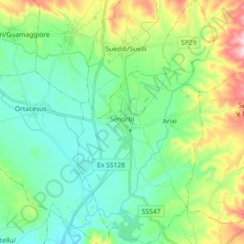
Name: Senorbì topographic map, elevation, terrain.
Location: Senorbì, Cagliari, Sardinia, 09040, Italy (39.48581 9.10760 39.58186 9.17722)
Average elevation: 227 m
Minimum elevation: 134 m
Maximum elevation: 476 m
Thank you for supporting this site ❤️
Make a donation
Make a donation
Gear up for your next adventure:
As an Amazon Associate, this site earns from qualifying purchases at no extra cost to you.
Other topographic maps
Click on a map to view its topography, its elevation and its terrain.
Monte Maria
Italy > Sardinia > Cagliari > Quartu Sant'Aleni/Quartu Sant'Elena
Average elevation: 504 m