
Make a donation
Gear up for your next adventure:
As an Amazon Associate, this site earns from qualifying purchases at no extra cost to you.
Pinetown topographic map
Click on the map to display elevation.
Make a donation
Gear up for your next adventure:
As an Amazon Associate, this site earns from qualifying purchases at no extra cost to you.
Pinetown
Topographically, Pinetown is generally hilly with the exception of the central business district which is relatively flatter by comparison to the surrounding suburban areas. The notable high-lying areas in the eastern parts of Pinetown include Cowies Hill and the New Germany Nature Reserve reaching approximately 400 m (1312 ft) above sea level. In the northern parts, the suburb of Berkshire Downs in New Germany reaches approximately 393 m (1289 ft) above sea level. The lowest elevations of Pinetown are found in the southern parts, which approximately range between 170 m (558 ft) and 300m (984 ft) above sea level.
Make a donation
Gear up for your next adventure:
As an Amazon Associate, this site earns from qualifying purchases at no extra cost to you.
About this map
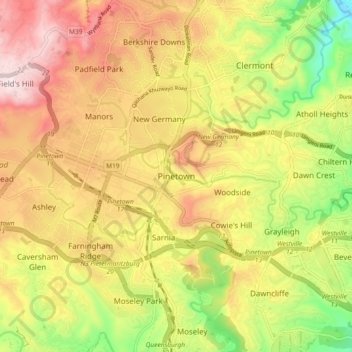
Name: Pinetown topographic map, elevation, terrain.
Average elevation: 296 m
Minimum elevation: 13 m
Maximum elevation: 554 m
Make a donation
Gear up for your next adventure:
As an Amazon Associate, this site earns from qualifying purchases at no extra cost to you.