
Melissant topographic map
Interactive map
Click on the map to display elevation.
About this map
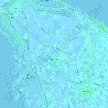
Name: Melissant topographic map, elevation, terrain.
Location: Melissant, Goeree-Overflakkee, Zuid-Holland, Nederland (51.75156 3.99694 51.79601 4.11625)
Average elevation: 0 m
Minimum elevation: -4 m
Maximum elevation: 5 m
Other topographic maps
Click on a map to view its topography, its elevation and its terrain.
Breede Gooi
Nederland > Zuid-Holland > Goeree-Overflakkee
Breede Gooi, Goeree-Overflakkee, Zuid-Holland, Nederland, 3247XX, Nederland
Average elevation: 1 m
Herkingen
Nederland > Zuid-Holland > Goeree-Overflakkee
Herkingen, Goeree-Overflakkee, Zuid-Holland, Nederland
Average elevation: 0 m
Breede Gooi
Nederland > Zuid-Holland > Goeree-Overflakkee
Breede Gooi, Goeree-Overflakkee, Zuid-Holland, Nederland, 3247KB, Nederland
Average elevation: 1 m