
Make a donation
Gear up for your next adventure:
As an Amazon Associate, this site earns from qualifying purchases at no extra cost to you.
Tigard topographic map
Click on the map to display elevation.
Make a donation
Gear up for your next adventure:
As an Amazon Associate, this site earns from qualifying purchases at no extra cost to you.
About this map
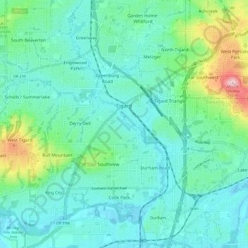
Name: Tigard topographic map, elevation, terrain.
Location: Tigard, Washington County, Oregon, United States (45.39324 -122.85692 45.45643 -122.74342)
Average elevation: 83 m
Minimum elevation: 31 m
Maximum elevation: 288 m
Make a donation
Gear up for your next adventure:
As an Amazon Associate, this site earns from qualifying purchases at no extra cost to you.
Other topographic maps
Click on a map to view its topography, its elevation and its terrain.
Make a donation
Gear up for your next adventure:
As an Amazon Associate, this site earns from qualifying purchases at no extra cost to you.
Vern Galaway Memorial Park
United States > Oregon > Washington County > North Plains
Average elevation: 56 m