
La Trappe topographic map
Interactive map
Click on the map to display elevation.
About this map
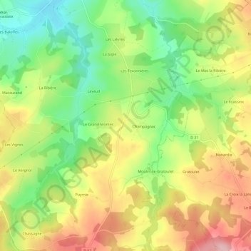
Name: La Trappe topographic map, elevation, terrain.
Average elevation: 366 m
Minimum elevation: 281 m
Maximum elevation: 461 m
Other topographic maps
Click on a map to view its topography, its elevation and its terrain.
Le Pigeonnier
France > Nouvelle-Aquitaine > Haute-Vienne > Saint-Priest-Ligoure > Le Pigeonnier
Le Pigeonnier, Saint-Priest-Ligoure, Limoges, Haute-Vienne, Nouvelle-Aquitaine, France métropolitaine, 87800, France
Average elevation: 327 m