
Pamproux topographic map
Interactive map
Click on the map to display elevation.
About this map
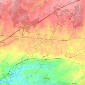
Name: Pamproux topographic map, elevation, terrain.
Average elevation: 143 m
Minimum elevation: 73 m
Maximum elevation: 187 m
Other topographic maps
Click on a map to view its topography, its elevation and its terrain.
Le Mont Dore
France > Nouvelle-Aquitaine > Deux-Sèvres > Gourgé
Le Mont Dore, Gourgé, Parthenay, Deux-Sèvres, Nouvelle-Aquitaine, France métropolitaine, 79200, France
Average elevation: 136 m
Saint Maurice Étusson
France > Nouvelle-Aquitaine > Deux-Sèvres
Saint Maurice Étusson, Bressuire, Deux-Sèvres, Nouvelle-Aquitaine, France métropolitaine, 79150, France
Average elevation: 128 m