
Saint-Épiphane topographic map
Interactive map
Click on the map to display elevation.
About this map
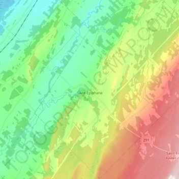
Name: Saint-Épiphane topographic map, elevation, terrain.
Average elevation: 157 m
Minimum elevation: 47 m
Maximum elevation: 350 m
Other topographic maps
Click on a map to view its topography, its elevation and its terrain.
Saint-Modeste
Canada > Québec > Rivière-du-Loup (MRC)
Saint-Modeste, Rivière-du-Loup (MRC), Bas-Saint-Laurent, Québec, Canada
Average elevation: 173 m
L'Isle-Verte
Canada > Québec > Rivière-du-Loup (MRC)
L'Isle-Verte, Rivière-du-Loup (MRC), Bas-Saint-Laurent, Québec, G0L 1K0, Canada
Average elevation: 53 m
Rivière-du-Loup
Canada > Québec > Rivière-du-Loup (MRC)
Rivière-du-Loup, Rivière-du-Loup (MRC), Bas-Saint-Laurent, Québec, Canada
Average elevation: 64 m
L'Isle-Verte
Canada > Québec > Rivière-du-Loup (MRC) > L'Isle-Verte > L'Isle-Verte
L'Isle-Verte, Rivière-du-Loup (MRC), Bas-Saint-Laurent, Québec, G0L 1K0, Canada
Average elevation: 19 m