
Sverige topographic map
Interactive map
Click on the map to display elevation.
About this map
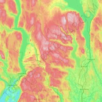
Name: Sverige topographic map, elevation, terrain.
Location: Sverige, Gran, Innlandet, Norvège (60.05888 10.43128 60.69888 11.07128)
Average elevation: 357 m
Minimum elevation: 56 m
Maximum elevation: 840 m
Other topographic maps
Click on a map to view its topography, its elevation and its terrain.
Viewpoint Snøhetta
Viewpoint Snøhetta, Vålåsjøhøvegen, Dovre, Innlandet, 2661, Norvège
Average elevation: 1,157 m