
Bowen Island topographic map
Interactive map
Click on the map to display elevation.
About this map
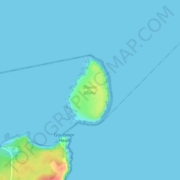
Name: Bowen Island topographic map, elevation, terrain.
Location: Bowen Island, Jervis Bay Territory, Australia (-35.12263 150.76389 -35.11223 150.77212)
Average elevation: 4 m
Minimum elevation: 0 m
Maximum elevation: 52 m
Other topographic maps
Click on a map to view its topography, its elevation and its terrain.
Booderee National Park
Australia > Jervis Bay Territory > Wreck Bay Aboriginal Community
Booderee National Park, Wreck Bay Aboriginal Community, Shoalhaven City Council, Jervis Bay Territory, Australia
Average elevation: 14 m