Geolocate

Dublin topographic map

Click on the map to display elevation.

About this map

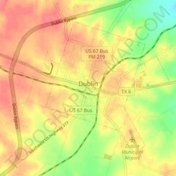
Name: Dublin topographic map, elevation, terrain.

Location: Dublin, Erath County, Texas, 76446, United States (32.06514 -98.37524 32.10461 -98.31343)

Average elevation: 451 m

Minimum elevation: 414 m

Maximum elevation: 474 m

Gear up for your next adventure:

🪢Paracord - Multi-purpose survival cord
🛌Sleeping Mats - Insulated mats for camping comfort
🏕️Camping Gear - Essential camping equipment
🔌Fast Charging Adapters - Quickly top up all your gear before heading back into the field
👄SPF Lip Balm - Prevent sun and wind-burnt lips on mountain ridges

As an Amazon Associate, this site earns from qualifying purchases at no extra cost to you.