
Beilngries topographic map
Interactive map
Click on the map to display elevation.
About this map
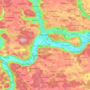
Name: Beilngries topographic map, elevation, terrain.
Location: Beilngries, Landkreis Eichstätt, Beieren, 92339, Duitsland (48.95162 11.38549 49.08770 11.59514)
Average elevation: 480 m
Minimum elevation: 358 m
Maximum elevation: 575 m
Other topographic maps
Click on a map to view its topography, its elevation and its terrain.
Stammham
Duitsland > Beieren > Landkreis Eichstätt
Stammham, Landkreis Eichstätt, Beieren, 85134, Duitsland
Average elevation: 466 m