
Make a donation
Gear up for your next adventure:
As an Amazon Associate, this site earns from qualifying purchases at no extra cost to you.
Pokhara topographic map
Click on the map to display elevation.
Make a donation
Gear up for your next adventure:
As an Amazon Associate, this site earns from qualifying purchases at no extra cost to you.
Pokhara
Pokhara (Nepali: पोखरा, Nepali pronunciation: [ˈpokʰʌɾa]) is a metropolitan city in Nepal, which serves as the capital of Gandaki Province. It is the second most populous city of Nepal after Kathmandu, with 518,452 inhabitants living in 101,669 households in 2021. It is the country's largest metropolitan city in terms of area. The city also serves as the headquarters of Kaski District. Pokhara is located 200 kilometres (120 miles) west of the capital, Kathmandu. The city is on the shore of Phewa Lake, and sits at an elevation of approximately 822m. The Annapurna Range, with three out of the ten highest peaks in the world—Dhaulagiri, Annapurna I and Manaslu—is within 15–35 mi (24–56 km) of the valley.
Make a donation
Gear up for your next adventure:
As an Amazon Associate, this site earns from qualifying purchases at no extra cost to you.
About this map
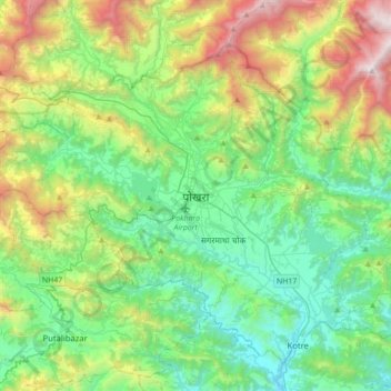
Name: Pokhara topographic map, elevation, terrain.
Location: Pokhara, Kaski, Gandaki Province, Nepal (28.07773 83.79872 28.34122 84.14745)
Average elevation: 1,203 m
Minimum elevation: 485 m
Maximum elevation: 3,058 m
Make a donation
Gear up for your next adventure:
As an Amazon Associate, this site earns from qualifying purchases at no extra cost to you.
Other topographic maps
Click on a map to view its topography, its elevation and its terrain.
Machapuchare
Nepal > Gandaki Province > Kaski
Due to its southern position in the range and the particularly low terrain that lies south of the Annapurna Himalayas, which contains three of the 10 highest peaks in the world, Machapuchare commands tremendous vertical relief in a short horizontal distance. This, combined with its steep, pointed profile,…
Average elevation: 5,746 m
Make a donation
Gear up for your next adventure:
As an Amazon Associate, this site earns from qualifying purchases at no extra cost to you.
Sarangkot
Nepal > Gandaki Province > Kaski > Pokhara
The Ward is located on Sarangkot, a hill on the western side of Pokhara with an altitude of 1600m. Sarangkot is known for its panoramic Himalayan views of Dhaulagiri, Annapurna and Manaslu. It also provides an expansive view of the city of Pokhara, from the extreme north to the south including Phewa Lake.…
Average elevation: 1,139 m
Make a donation
Gear up for your next adventure:
As an Amazon Associate, this site earns from qualifying purchases at no extra cost to you.
Make a donation
Gear up for your next adventure:
As an Amazon Associate, this site earns from qualifying purchases at no extra cost to you.
Make a donation
Gear up for your next adventure:
As an Amazon Associate, this site earns from qualifying purchases at no extra cost to you.
Hadeban Upabhokta Samiti , Lamachaur -19
Nepal > Gandaki Province > Kaski > Pokhara
Average elevation: 1,042 m
Make a donation
Gear up for your next adventure:
As an Amazon Associate, this site earns from qualifying purchases at no extra cost to you.
Make a donation
Gear up for your next adventure:
As an Amazon Associate, this site earns from qualifying purchases at no extra cost to you.
Make a donation
Gear up for your next adventure:
As an Amazon Associate, this site earns from qualifying purchases at no extra cost to you.
Make a donation
Gear up for your next adventure:
As an Amazon Associate, this site earns from qualifying purchases at no extra cost to you.