
Thank you for supporting this site ❤️
Make a donation
Make a donation
Gear up for your next adventure:
As an Amazon Associate, this site earns from qualifying purchases at no extra cost to you.
Écône topographic map
Click on the map to display elevation.
Thank you for supporting this site ❤️
Make a donation
Make a donation
Gear up for your next adventure:
As an Amazon Associate, this site earns from qualifying purchases at no extra cost to you.
About this map
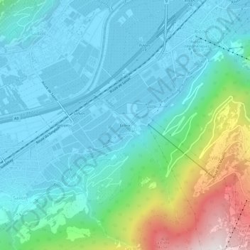
Name: Écône topographic map, elevation, terrain.
Location: Écône, Saxon, Martigny, Valais, 1908, Suisse (46.13691 7.18501 46.17691 7.22501)
Average elevation: 753 m
Minimum elevation: 463 m
Maximum elevation: 1,898 m
Thank you for supporting this site ❤️
Make a donation
Make a donation
Gear up for your next adventure:
As an Amazon Associate, this site earns from qualifying purchases at no extra cost to you.