
Thank you for supporting this site ❤️
Make a donation
Make a donation
Gear up for your next adventure:
As an Amazon Associate, this site earns from qualifying purchases at no extra cost to you.
Temascaltepec topographic map
Click on the map to display elevation.
Thank you for supporting this site ❤️
Make a donation
Make a donation
Gear up for your next adventure:
As an Amazon Associate, this site earns from qualifying purchases at no extra cost to you.
About this map
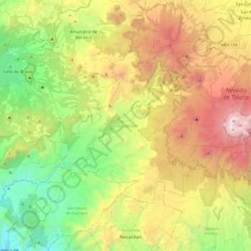
Name: Temascaltepec topographic map, elevation, terrain.
Location: Temascaltepec, State of Mexico, Mexico (18.97898 -100.24011 19.23626 -99.81645)
Average elevation: 2,604 m
Minimum elevation: 1,340 m
Maximum elevation: 4,643 m
Thank you for supporting this site ❤️
Make a donation
Make a donation
Gear up for your next adventure:
As an Amazon Associate, this site earns from qualifying purchases at no extra cost to you.
Other topographic maps
Click on a map to view its topography, its elevation and its terrain.
Barrio la Cascada (Barrio del Varal)
Mexico > State of Mexico > Temascaltepec
Average elevation: 1,872 m