Geolocate

Gimse topographic map

Click on the map to display elevation.

About this map

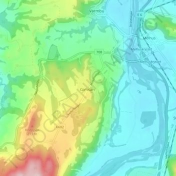
Name: Gimse topographic map, elevation, terrain.

Location: Gimse, Melhus, Trøndelag, 7227, Norway (63.25455 10.22637 63.29455 10.26637)

Average elevation: 76 m

Minimum elevation: 4 m

Maximum elevation: 277 m

Gear up for your next adventure:

🌿Flora and Fauna Field Guides - Identify the plants and animals you encounter on your route
📸Action Cameras - Record your journey across interesting topographic features in 4K
🎒Ultralight Backpacks - Lightweight packs for long hikes
🔦Headlamps - Hands-free lighting for hiking
🛌Compact Down Sleeping Bags - Warmth without the bulk, ideal for backcountry camping

As an Amazon Associate, this site earns from qualifying purchases at no extra cost to you.