Geolocate

Puncan topographic map

Click on the map to display elevation.

About this map

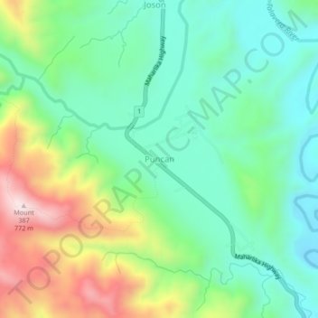
Name: Puncan topographic map, elevation, terrain.

Location: Puncan, Carranglan, Nueva Ecija, Central Luzon, Philippines (15.88615 120.97185 15.92615 121.01185)

Average elevation: 380 m

Minimum elevation: 191 m

Maximum elevation: 773 m

Gear up for your next adventure:

🎧Bluetooth Outdoor Earbuds - Listen to navigation cues or podcasts during long solo treks
🆘Personal Locator Beacons (PLB) - Satellite emergency beacons for life-saving help in areas with no mobile coverage
🧭Military Style Lensatic Compass - Durable sighting compasses for advanced land navigation and surveying
🔋Rechargeable Batteries - Eco-friendly power for high-drain GPS units and flashlights
🧊Insulated Cooler Bags - Keep food fresh for day trips to remote geographic sites

As an Amazon Associate, this site earns from qualifying purchases at no extra cost to you.