
Fish Lake topographic map
Click on the map to display elevation.
Fish Lake
Fish Lake is a high alpine lake (elevation approximately 8,848 ft or 2,700 m) located in the Fishlake/ Southern Wasatch Plateau region of south-central Utah, United States. It lies within and is the namesake of the Fishlake National Forest.
About this map
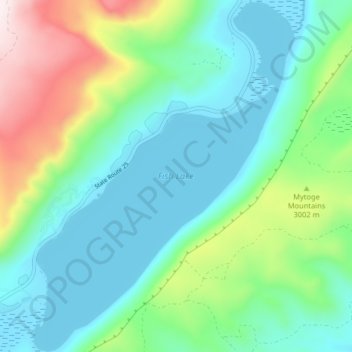
Name: Fish Lake topographic map, elevation, terrain.
Location: Fish Lake, Sevier County, Utah, United States (38.51973 -111.73857 38.58301 -111.67746)
Average elevation: 2,886 m
Minimum elevation: 2,694 m
Maximum elevation: 3,438 m
Other topographic maps
Click on a map to view its topography, its elevation and its terrain.