Geolocate

Shorne topographic map

Click on the map to display elevation.

About this map

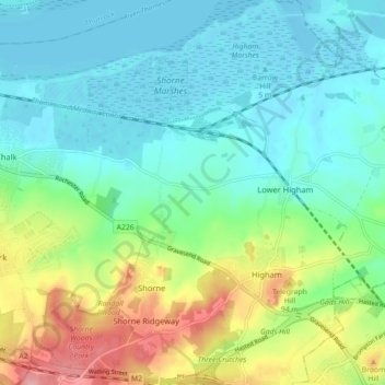
Name: Shorne topographic map, elevation, terrain.

Location: Shorne, Higham, Gravesham, Kent, England, United Kingdom (51.39906 0.38786 51.45466 0.45709)

Average elevation: 35 m

Minimum elevation: -2 m

Maximum elevation: 123 m

Other topographic maps

Click on a map to view its topography, its elevation and its terrain.

Little Hermitage

United Kingdom > England > Kent > Gravesham > Higham

Average elevation: 49 m

Gear up for your next adventure:

🧭Military Style Lensatic Compass - Durable sighting compasses for advanced land navigation and surveying
Altimeter Barometer Watches - Outdoor watches with built-in sensors to track altitude changes and weather shifts
🎨Portable Watercolor Kits - Paint the landscapes and topographic views you discover
📡Weather Radios - Emergency weather radios
🦯Trekking Poles - Walking poles for hiking stability

As an Amazon Associate, this site earns from qualifying purchases at no extra cost to you.