
Menzenschwand Hinterdorf topographic map
Interactive map
Click on the map to display elevation.
About this map
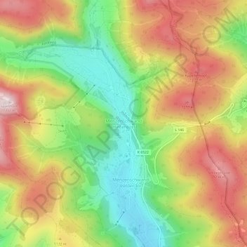
Name: Menzenschwand Hinterdorf topographic map, elevation, terrain.
Average elevation: 1,084 m
Minimum elevation: 839 m
Maximum elevation: 1,345 m
Other topographic maps
Click on a map to view its topography, its elevation and its terrain.
Menzenschwand-Vorderdorf
Allemagne > Bade-Wurtemberg > Landkreis Waldshut > St. Blasien
Menzenschwand-Vorderdorf, St. Blasien, Verwaltungsverband St. Blasien, Landkreis Waldshut, Bade-Wurtemberg, 79872, Allemagne
Average elevation: 1,059 m