
Blair Village topographic map
Interactive map
Click on the map to display elevation.
About this map
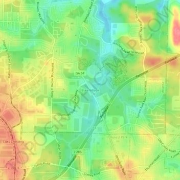
Name: Blair Village topographic map, elevation, terrain.
Average elevation: 275 m
Minimum elevation: 240 m
Maximum elevation: 314 m
Other topographic maps
Click on a map to view its topography, its elevation and its terrain.
Bolton
United States > Georgia > Fulton County > Atlanta
Bolton, Atlanta, Fulton County, Georgia, 30369, United States
Average elevation: 259 m
Atlanta Memorial Park
United States > Georgia > Fulton County > Atlanta
Atlanta Memorial Park, Atlanta, Fulton County, Georgia, United States
Average elevation: 263 m
Piedmont Park
United States > Georgia > Fulton County > Atlanta
Piedmont Park, Atlanta, Fulton County, Georgia, 30306, United States
Average elevation: 283 m
Hills Park
United States > Georgia > Fulton County > Atlanta
Hills Park, Atlanta, Fulton County, Georgia, 30318, United States
Average elevation: 269 m
Capital City Country Club Lake Dam
United States > Georgia > Fulton County > Atlanta
Capital City Country Club Lake Dam, Atlanta, Fulton County, Georgia, 30319, United States
Average elevation: 294 m
Simsville
United States > Georgia > Fulton County > Atlanta > Simsville
Simsville, Atlanta, Fulton County, Georgia, 30318, United States
Average elevation: 275 m
Egan Park
United States > Georgia > Fulton County > Atlanta > Egan Park
Egan Park, Atlanta, Fulton County, Georgia, 30344, United States
Average elevation: 307 m