
Make a donation
Gear up for your next adventure:
As an Amazon Associate, this site earns from qualifying purchases at no extra cost to you.
Pelham topographic map
Click on the map to display elevation.
Make a donation
Gear up for your next adventure:
As an Amazon Associate, this site earns from qualifying purchases at no extra cost to you.
Pelham
From the top of the Fonthill Kame Delta hill, a unique topographical feature (Ontario Geological Society 1970) and ANSI protected site (Area of Natural Scientific Interest - ANSI) on a clear day it is possible to see Toronto, Hamilton and western New York state. At one time, a ski tow was installed on the north side of the Kame Delta Hill on what is now Lookout Point Golf and Country Club, but it was a commercial failure and no longer operates.
Make a donation
Gear up for your next adventure:
As an Amazon Associate, this site earns from qualifying purchases at no extra cost to you.
About this map
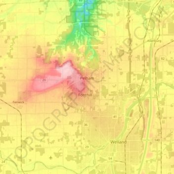
Name: Pelham topographic map, elevation, terrain.
Location: Pelham, Niagara Region, Golden Horseshoe, Ontario, Canada (42.96566 -79.39016 43.10865 -79.26739)
Average elevation: 183 m
Minimum elevation: 94 m
Maximum elevation: 260 m
Make a donation
Gear up for your next adventure:
As an Amazon Associate, this site earns from qualifying purchases at no extra cost to you.