
Monticello topographic map
Interactive map
Click on the map to display elevation.
About this map
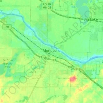
Name: Monticello topographic map, elevation, terrain.
Location: Monticello, Wright County, Minnesota, 55362, United States (45.27053 -93.86106 45.33840 -93.73503)
Average elevation: 289 m
Minimum elevation: 270 m
Maximum elevation: 327 m
According to the U.S. Census Bureau, the city has a total area of 8.94 square miles (23.15 km2), all land. The city's latitude is 45.305 degrees North and its longitude is 93.793 degrees West. Its elevation is 922 feet. Monticello is in the Central time zone.
Other topographic maps
Click on a map to view its topography, its elevation and its terrain.
Rockford
United States > Minnesota > Wright County
Rockford, Wright County, Minnesota, United States
Average elevation: 296 m
Delano
United States > Minnesota > Wright County
Delano, Wright County, Minnesota, 55328, United States
Average elevation: 289 m
Otsego
United States > Minnesota > Wright County
Otsego, Wright County, Minnesota, United States
Average elevation: 281 m
Monticello Township
United States > Minnesota > Wright County
Monticello Township, Wright County, Minnesota, United States
Average elevation: 297 m
Albertville
United States > Minnesota > Wright County
Albertville, Wright County, Minnesota, 55301, United States
Average elevation: 292 m
Hanover
United States > Minnesota > Wright County
Hanover, Wright County, Minnesota, 55341, United States
Average elevation: 291 m
Montrose
United States > Minnesota > Wright County
Montrose, Wright County, Minnesota, United States
Average elevation: 294 m
Howard Lake
United States > Minnesota > Wright County
Howard Lake, Wright County, Minnesota, 55349, United States
Average elevation: 312 m
Buffalo
United States > Minnesota > Wright County
Buffalo, Wright County, Minnesota, 55313, United States
Average elevation: 297 m
Silver Creek Township
United States > Minnesota > Wright County
Silver Creek Township, Wright County, Minnesota, 55380, United States
Average elevation: 303 m
Albion Center
United States > Minnesota > Wright County
Albion Center, Albion Township, Wright County, Minnesota, United States
Average elevation: 320 m
St. Michael
United States > Minnesota > Wright County
St. Michael, Wright County, Minnesota, 55376, United States
Average elevation: 290 m
Maple Lake Township
United States > Minnesota > Wright County
Maple Lake Township, Wright County, Minnesota, 55358, United States
Average elevation: 310 m
South Haven
United States > Minnesota > Wright County
South Haven, Wright County, Minnesota, United States
Average elevation: 333 m
Maple Lake
United States > Minnesota > Wright County > Maple Lake > Maple Lake
Maple Lake, Wright County, Minnesota, 55358, United States
Average elevation: 314 m
South Haven
United States > Minnesota > Wright County > South Haven > South Haven
South Haven, Wright County, Minnesota, 55382, United States
Average elevation: 331 m
Rockford
United States > Minnesota > Wright County > Rockford > Rockford
Rockford, Wright County, Minnesota, 55313:55373, United States
Average elevation: 298 m
Annandale
United States > Minnesota > Wright County > Annandale > Annandale
Annandale, Wright County, Minnesota, 55302, United States
Average elevation: 324 m
Annandale
United States > Minnesota > Wright County
Annandale, Wright County, Minnesota, 55302, United States
Average elevation: 323 m
Maple Lake
United States > Minnesota > Wright County
Maple Lake, Wright County, Minnesota, United States
Average elevation: 314 m