Geolocate

Anacortes topographic map

Click on the map to display elevation.

About this map

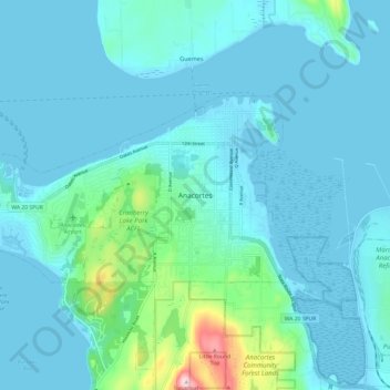
Name: Anacortes topographic map, elevation, terrain.

Location: Anacortes, Skagit County, Washington, 98221, United States (48.46201 -122.66374 48.54201 -122.58374)

Average elevation: 37 m

Minimum elevation: -2 m

Maximum elevation: 315 m

Gear up for your next adventure:

🦟Insect Repellent - Protection against insects
💡Collapsible Camping Lanterns - Illuminate your base camp or tent for map studying at night
🧴SPF 50+ Bulk Sunscreen - Maximum protection for long-term outdoor exposure
🩹First Aid Kits - Emergency kits for hiking
🕶️Polarized Sunglasses - UV protection sunglasses for outdoors

As an Amazon Associate, this site earns from qualifying purchases at no extra cost to you.