
Centennial Park topographic map
Interactive map
Click on the map to display elevation.
About this map
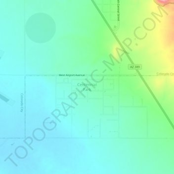
Name: Centennial Park topographic map, elevation, terrain.
Average elevation: 1,504 m
Minimum elevation: 1,472 m
Maximum elevation: 1,615 m
Other topographic maps
Click on a map to view its topography, its elevation and its terrain.
Hoover Dam
United States > Arizona > Mohave County
Hoover Dam, Mohave County, Arizona, United States
Average elevation: 429 m
Pyramid Rock
United States > Arizona > Mohave County
Pyramid Rock, Mohave County, Arizona, United States
Average elevation: 1,419 m
Lake Havasu City
United States > Arizona > Mohave County > Lake Havasu City
Lake Havasu City, Mohave County, Arizona, 86403, United States
Average elevation: 411 m