
Deigné topographic map
Interactive map
Click on the map to display elevation.
About this map
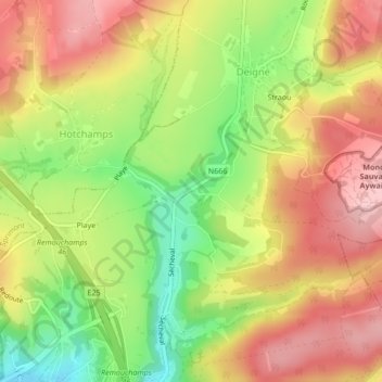
Name: Deigné topographic map, elevation, terrain.
Location: Deigné, Aywaille, Liège, Wallonie, 4920, Belgique (50.48867 5.71247 50.50867 5.73247)
Average elevation: 245 m
Minimum elevation: 151 m
Maximum elevation: 323 m
Other topographic maps
Click on a map to view its topography, its elevation and its terrain.
Chambralles
Belgique > Wallonie > Aywaille > Chambralles
Chambralles, Aywaille, Liège, Wallonie, 4920, Belgique
Average elevation: 215 m