
Santa Cruz topographic map
Interactive map
Click on the map to display elevation.
About this map
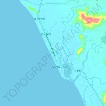
Name: Santa Cruz topographic map, elevation, terrain.
Location: Santa Cruz, Occidental Mindoro, Mimaropa, Philippines (13.04431 120.67690 13.12431 120.75690)
Average elevation: 7 m
Minimum elevation: 0 m
Maximum elevation: 154 m
Other topographic maps
Click on a map to view its topography, its elevation and its terrain.
San Vicente
Philippines > Occidental Mindoro > Santa Cruz
San Vicente, Santa Cruz, Occidental Mindoro, Mimaropa, Philippines
Average elevation: 4 m