
Make a donation
Gear up for your next adventure:
As an Amazon Associate, this site earns from qualifying purchases at no extra cost to you.
Kaveripattinam topographic map
Click on the map to display elevation.
Make a donation
Gear up for your next adventure:
As an Amazon Associate, this site earns from qualifying purchases at no extra cost to you.
Kaveripattinam
Kaveripattinam is located at 12°25′N 78°14′E / 12.42°N 78.23°E / 12.42; 78.23 on the NH 44, a major north–south National Highway, one of the longest and busiest road in the country. It has an average elevation of 533 metres (1,749 ft). This town has a cool climate. It lies on the bank of the river Then Pennai and it has a green and cool climate. It is located on NH-7. It is 100 kilometres (62 mi) from Bangalore, 30 kilometres (19 mi) from Dharmapuri, and 10 kilometres (6.2 mi) from Krishnagiri. The town is very green because of the KRP Dam nearby and rich in water resources.
Make a donation
Gear up for your next adventure:
As an Amazon Associate, this site earns from qualifying purchases at no extra cost to you.
About this map
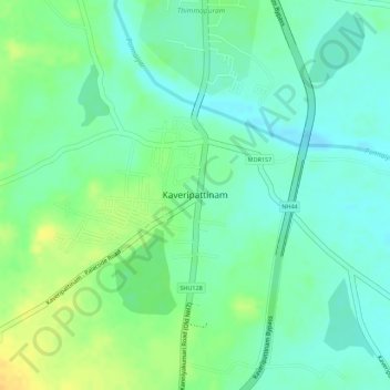
Name: Kaveripattinam topographic map, elevation, terrain.
Location: Kaveripattinam, Krishnagiri, Tamil Nadu, India (12.41248 78.20783 12.42451 78.22502)
Average elevation: 462 m
Minimum elevation: 449 m
Maximum elevation: 480 m
Make a donation
Gear up for your next adventure:
As an Amazon Associate, this site earns from qualifying purchases at no extra cost to you.
Other topographic maps
Click on a map to view its topography, its elevation and its terrain.