
Make a donation
Gear up for your next adventure:
As an Amazon Associate, this site earns from qualifying purchases at no extra cost to you.
Dagua topographic map
Click on the map to display elevation.
Make a donation
Gear up for your next adventure:
As an Amazon Associate, this site earns from qualifying purchases at no extra cost to you.
Dagua
Dagua es un municipio de Colombia en el departamento de Valle del Cauca, ubicado al occidente del departamento, entre los municipios de Buenaventura, Restrepo, La Cumbre y Calima, a 3º38'45" latitud norte y 76º41'30" longitud oeste. Tiene una temperatura media de 25 °C, una altitud de 828 metros sobre el nivel del mar. En su relieve se observan profundas simas y cumbres que le permiten contar con diversidad climática, abundantes fuentes hídricas y bosque protector en el cual se origina el sistema de cuencas y microcuencas que vierten su caudal al río Dagua que a su vez desemboca en la Bahía de Buenaventura sobre el Océano Pacífico. Ese río está siendo afectado intensamente por la minería ilegal en tramo de 20 kilómetros.
Make a donation
Gear up for your next adventure:
As an Amazon Associate, this site earns from qualifying purchases at no extra cost to you.
About this map
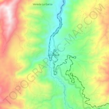
Name: Dagua topographic map, elevation, terrain.
Location: Dagua, Sur, Valle del Cauca, RAP Pacífico, Colombia (3.61816 -76.72940 3.69816 -76.64940)
Average elevation: 1,267 m
Minimum elevation: 745 m
Maximum elevation: 2,003 m
Make a donation
Gear up for your next adventure:
As an Amazon Associate, this site earns from qualifying purchases at no extra cost to you.
Other topographic maps
Click on a map to view its topography, its elevation and its terrain.
Reserva Natural de la Sociedad Civil El Carare
Colombia > Valle del Cauca > Dagua > San José del Salado
Average elevation: 1,477 m