
Orick topographic map
Interactive map
Click on the map to display elevation.
About this map
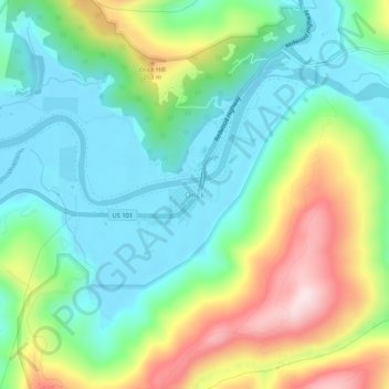
Name: Orick topographic map, elevation, terrain.
Average elevation: 125 m
Minimum elevation: -1 m
Maximum elevation: 385 m
Orick (formerly, Arekw, Orekw, and Oreq, Yurok: 'O'rekw ) is a census-designated place situated on the banks of the Redwood Creek in Humboldt County, California. It is located 43 miles (69 km) north of Eureka, at an elevation of 26 feet (8 m). The population was 357 at the 2010 census.