
Thank you for supporting this site ❤️
Make a donation
Make a donation
Gear up for your next adventure:
As an Amazon Associate, this site earns from qualifying purchases at no extra cost to you.
Alaska topographic map
Click on the map to display elevation.
Thank you for supporting this site ❤️
Make a donation
Make a donation
Gear up for your next adventure:
As an Amazon Associate, this site earns from qualifying purchases at no extra cost to you.
About this map
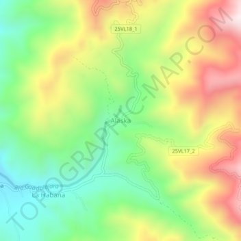
Name: Alaska topographic map, elevation, terrain.
Location: Alaska, Buga, Centro, Valle del Cauca, RAP Pacífico, Colombia (3.87207 -76.20185 3.91207 -76.16185)
Average elevation: 1,684 m
Minimum elevation: 1,359 m
Maximum elevation: 2,117 m
Thank you for supporting this site ❤️
Make a donation
Make a donation
Gear up for your next adventure:
As an Amazon Associate, this site earns from qualifying purchases at no extra cost to you.
Other topographic maps
Click on a map to view its topography, its elevation and its terrain.