Geolocate

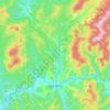
Kaz topographic map

Click on the map to display elevation.

About this map

Name: Kaz topographic map, elevation, terrain.

Location: Kaz, Tashtagolsky Municipal Okrug, Kemerovo Oblast–Kuzbass, Siberian Federal District, Russia (53.09904 87.52155 53.12597 87.63387)

Average elevation: 479 m

Minimum elevation: 324 m

Maximum elevation: 710 m

Other topographic maps

Click on a map to view its topography, its elevation and its terrain.

Gear up for your next adventure:

🏫Topographic World Globes - 3D physical relief globes to understand global geography
💧Personal Water Filters - Drink safely from streams and lakes identified on your map
🚁Camera Drones with GPS - Capture aerial views of the landscape to compare with topo maps
🔋Solar Power Banks - Charge your phone and GPS using the sun while deep in the bush
🎒3L Hydration Reservoirs - Hands-free drinking to stay hydrated on steep contour climbs

As an Amazon Associate, this site earns from qualifying purchases at no extra cost to you.