
Nargess Districts topographic map
Interactive map
Click on the map to display elevation.
About this map
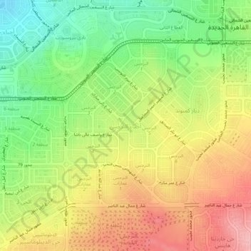
Name: Nargess Districts topographic map, elevation, terrain.
Location: Nargess Districts, New Cairo City, Cairo, 11835, Egypt (29.99200 31.43670 30.03200 31.47670)
Average elevation: 300 m
Minimum elevation: 228 m
Maximum elevation: 375 m
Other topographic maps
Click on a map to view its topography, its elevation and its terrain.
Lotus Districts
Egypt > Cairo > New Cairo City
Lotus Districts, New Cairo City, Cairo, 11865, Egypt
Average elevation: 314 m
Compound Hyde Park Damac
Egypt > Cairo > New Cairo City
Compound Hyde Park Damac, New Cairo City, Cairo, Egypt
Average elevation: 383 m
Banafseg Districts
Egypt > Cairo > New Cairo City
Banafseg Districts, New Cairo City, Cairo, 11865, Egypt
Average elevation: 241 m
Mividia Emaar Compound
Egypt > Cairo > New Cairo City
Mividia Emaar Compound, New Cairo City, Cairo, Egypt
Average elevation: 353 m
Kattameya Dunes Compound
Egypt > Cairo > New Cairo City
Kattameya Dunes Compound, New Cairo City, Cairo, Egypt
Average elevation: 353 m
Gate 5
Egypt > Cairo > New Cairo City
Gate 5, New Cairo City, Cairo, 11865, Egypt
Average elevation: 317 m
Districts of El Tagamoa El Khames
Egypt > Cairo > New Cairo City
Districts of El Tagamoa El Khames, New Cairo City, Cairo, 11936, Egypt
Average elevation: 278 m
Industrial District
Egypt > Cairo > New Cairo City
Industrial District, New Cairo City, Cairo, 11835, Egypt
Average elevation: 350 m
Mirage City
Egypt > Cairo > New Cairo City
Mirage City, New Cairo City, Cairo, Egypt
Average elevation: 190 m