Geolocate

Goldkronach topographic map

Click on the map to display elevation.

About this map
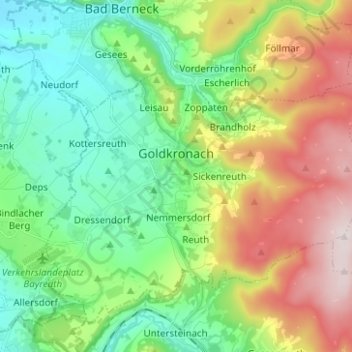
Name: Goldkronach topographic map, elevation, terrain.

Location: Goldkronach, Landkreis Bayreuth, Bavaria, 95497, Germany (49.97097 11.64089 50.02825 11.74379)

Average elevation: 546 m

Minimum elevation: 365 m

Maximum elevation: 857 m

Other topographic maps

Click on a map to view its topography, its elevation and its terrain.

Plösen

Germany > Bavaria > Landkreis Bayreuth

Average elevation: 449 m

Spies

Germany > Bavaria > Landkreis Bayreuth > Betzenstein

Average elevation: 534 m

Pfarrhügel

Germany > Bavaria > Landkreis Bayreuth > Eckersdorf

Average elevation: 507 m

Meinberg

Germany > Bavaria > Landkreis Bayreuth > Goldkronach

Average elevation: 450 m

Gottelhof

Germany > Bavaria > Landkreis Bayreuth > Hollfeld

Average elevation: 407 m

Reizendorf

Germany > Bavaria > Landkreis Bayreuth > Ahorntal

Average elevation: 435 m

Röhrig

Germany > Bavaria > Landkreis Bayreuth > Bindlacher Berg

Average elevation: 410 m

Gear up for your next adventure:

🔪Outdoor Multi-tools - Versatile tools for gear repair and survival tasks in the wilderness
👕UPF 50+ Sun Shirts - Essential protection against the harsh Australian sun during field work
🎽Base Layers - Thermal base layers
🦶Orthotic Hiking Insoles - Extra arch support for long-distance topographic treks
🔌Fast Charging Adapters - Quickly top up all your gear before heading back into the field

As an Amazon Associate, this site earns from qualifying purchases at no extra cost to you.