
Mukteshwar topographic map
Interactive map
Click on the map to display elevation.
About this map
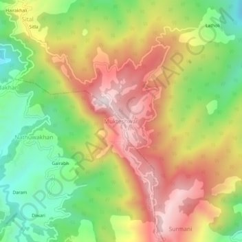
Name: Mukteshwar topographic map, elevation, terrain.
Location: Mukteshwar, Dhari, Nainital, Uttarakhand, 263138, India (29.45208 79.62804 29.49208 79.66804)
Average elevation: 1,982 m
Minimum elevation: 1,653 m
Maximum elevation: 2,323 m
Other topographic maps
Click on a map to view its topography, its elevation and its terrain.
Paharpani
India > Uttarakhand > Dhari > Mahtoligaon
Paharpani, Mahtoligaon, Dhari, Nainital District, Uttarakhand, India
Average elevation: 1,918 m
Thali
India > Uttarakhand > Dhari
Thali, Dhari, Nainital District, Uttarakhand, India
Average elevation: 1,889 m