
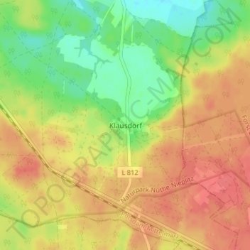
Klausdorf topographic map
Interactive map
Click on the map to display elevation.
About this map
Name: Klausdorf topographic map, elevation, terrain.
Average elevation: 91 m
Minimum elevation: 60 m
Maximum elevation: 114 m
Other topographic maps
Click on a map to view its topography, its elevation and its terrain.
Brachwitz
Deutschland > Brandenburg > Potsdam-Mittelmark > Treuenbrietzen
Brachwitz, Treuenbrietzen, Potsdam-Mittelmark, Brandenburg, Deutschland
Average elevation: 45 m
Bardenitz
Deutschland > Brandenburg > Potsdam-Mittelmark > Treuenbrietzen
Bardenitz, Treuenbrietzen, Potsdam-Mittelmark, Brandenburg, Deutschland
Average elevation: 71 m
Marzahna
Deutschland > Brandenburg > Potsdam-Mittelmark > Treuenbrietzen
Marzahna, Treuenbrietzen, Potsdam-Mittelmark, Brandenburg, Deutschland
Average elevation: 130 m