
Barragem da Crestuma-Lever topographic map
Interactive map
Click on the map to display elevation.
About this map
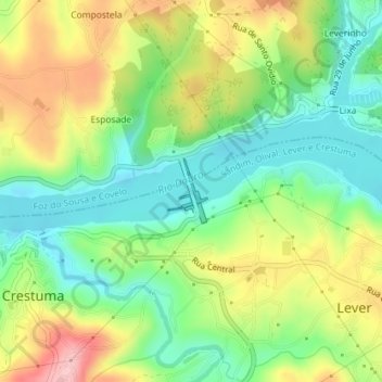
Name: Barragem da Crestuma-Lever topographic map, elevation, terrain.
Average elevation: 72 m
Minimum elevation: 3 m
Maximum elevation: 173 m
Crestuma–Lever Dam is a 25.5 m tall (height above foundation) and 470 m long gravity dam with a crest altitude of 25.5 m. The volume of the dam is 205,000 m³. The spillway with 8 gates is part of the dam body (maximum discharge 26,000 m³/s).