Geolocate

Hitzacker (Elbe) topographic map

Click on the map to display elevation.

About this map
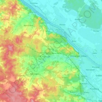
Name: Hitzacker (Elbe) topographic map, elevation, terrain.

Location: Hitzacker (Elbe), Samtgemeinde Elbtalaue, Landkreis Lüchow-Dannenberg, Lower Saxony, 29456, Germany (53.11282 10.89971 53.20268 11.09790)

Average elevation: 27 m

Minimum elevation: 6 m

Maximum elevation: 123 m

Other topographic maps

Click on a map to view its topography, its elevation and its terrain.
Gear up for your next adventure:

🧢Outdoor Sun Hats - Sun protection hats for hiking
🧭Global Orienteering Compass - High-precision liquid-filled compasses for accurate map reading and navigation
🥶Thermal Beanies - Warm hats for cold hikes
🍶Collapsible Water Bottles - Save space in your pack as you consume your water supply
☀️Portable Solar Chargers - High-efficiency panels to hang on your backpack while walking

As an Amazon Associate, this site earns from qualifying purchases at no extra cost to you.