
Thank you for supporting this site ❤️
Make a donation
Make a donation
Gear up for your next adventure:
As an Amazon Associate, this site earns from qualifying purchases at no extra cost to you.
Weiliu topographic map
Click on the map to display elevation.
Thank you for supporting this site ❤️
Make a donation
Make a donation
Gear up for your next adventure:
As an Amazon Associate, this site earns from qualifying purchases at no extra cost to you.
About this map
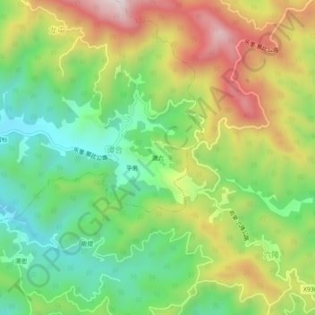
Name: Weiliu topographic map, elevation, terrain.
Location: Weiliu, Bagui, Tianlin County, Baise, Guangxi, China (24.15490 106.02200 24.19490 106.06200)
Average elevation: 669 m
Minimum elevation: 408 m
Maximum elevation: 1,035 m
Thank you for supporting this site ❤️
Make a donation
Make a donation
Gear up for your next adventure:
As an Amazon Associate, this site earns from qualifying purchases at no extra cost to you.