
Das topographic map
Interactive map
Click on the map to display elevation.
About this map
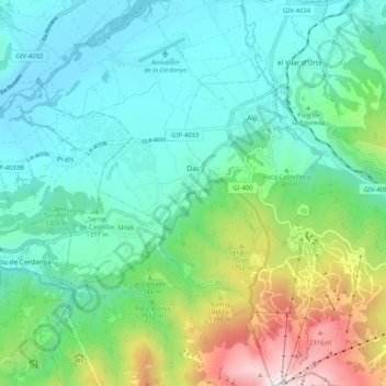
Name: Das topographic map, elevation, terrain.
Location: Das, Cerdaña, Gerona, Cataluña, España (42.32058 1.83205 42.39673 1.90230)
Average elevation: 1,404 m
Minimum elevation: 1,032 m
Maximum elevation: 2,536 m
Other topographic maps
Click on a map to view its topography, its elevation and its terrain.
Sanavastre
España > Cataluña > Cerdaña > Das
Sanavastre, Das, Cerdaña, Gerona, Cataluña, 17539, España
Average elevation: 1,091 m