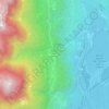
Kalterer See topographic map
Click on the map to display elevation.
Kalterer See
Der See ist 1,8 km lang, 0,9 km breit und an der tiefsten Stelle 5,6 m tief. Die Fläche beträgt 1,47 km². Er liegt auf einer Höhe von 215 m s.l.m. in einer Senke, einem Überbleibsel eines alten Flussbetts der Etsch, in der Gemeinde Kaltern etwa 14 km südlich der Stadt Bozen. Westseitig bieten sanfte Hänge der Kalterer Fraktion St. Josef am See Platz, ehe das Gelände steil zum Mendelkamm ansteigt. Ostseitig befindet sich die kleine zur Gemeinde Pfatten gehörende Ortschaft Klughammer, die unmittelbar vom Mitterberg am Kreiter Sattel überragt wird.
About this map

Name: Kalterer See topographic map, elevation, terrain.
Average elevation: 304 m
Minimum elevation: 203 m
Maximum elevation: 634 m
Other topographic maps
Click on a map to view its topography, its elevation and its terrain.