
Thank you for supporting this site ❤️
Make a donation
Make a donation
Gear up for your next adventure:
As an Amazon Associate, this site earns from qualifying purchases at no extra cost to you.
Oppenrod topographic map
Click on the map to display elevation.
Thank you for supporting this site ❤️
Make a donation
Make a donation
Gear up for your next adventure:
As an Amazon Associate, this site earns from qualifying purchases at no extra cost to you.
Oppenrod
Die Statistisch-topographisch-historische Beschreibung des Großherzogthums Hessen berichtet 1830 über das Busecker Tal.
Thank you for supporting this site ❤️
Make a donation
Make a donation
Gear up for your next adventure:
🛰️Handheld GPS Units - Rugged GPS devices for tracking coordinates and elevation in the Australian bush
As an Amazon Associate, this site earns from qualifying purchases at no extra cost to you.
About this map
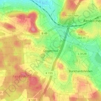
Name: Oppenrod topographic map, elevation, terrain.
Location: Oppenrod, Buseck, Landkreis Gießen, Hessen, 35418, Deutschland (50.56494 8.78168 50.60494 8.82168)
Average elevation: 236 m
Minimum elevation: 191 m
Maximum elevation: 279 m
Thank you for supporting this site ❤️
Make a donation
Make a donation
Gear up for your next adventure:
As an Amazon Associate, this site earns from qualifying purchases at no extra cost to you.