Geolocate
👉 Easily get elevation data in JSON, GeoTIFF and KML formats using Elevation API
Thank you for supporting this site ❤️
Make a donation

Gear up for your next adventure:

As an Amazon Associate, this site earns from qualifying purchases at no extra cost to you.

Killin topographic map

Click on the map to display elevation.

About this map

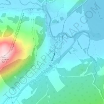
Name: Killin topographic map, elevation, terrain.

Location: Killin, Stirling, Scotland, United Kingdom (56.45787 -4.33292 56.47497 -4.31228)

Average elevation: 174 m

Minimum elevation: 106 m

Maximum elevation: 517 m

Other topographic maps

Click on a map to view its topography, its elevation and its terrain.

Gargunnock

United Kingdom > Scotland > Stirling

Average elevation: 94 m

Dunblane

United Kingdom > Scotland > Stirling

Average elevation: 117 m

Bridge of Allan

United Kingdom > Scotland > Stirling

Average elevation: 80 m

Killearn

United Kingdom > Scotland > Stirling > Killearn

Average elevation: 82 m

Gear up for your next adventure:

📚Map Reading & Navigation Guides - Master the art of interpreting topographic contours and symbols
🧭Compass - Navigation compasses for outdoor exploration
🥤Hydration Packs - Hydration systems for hiking
🧰Survival Kits - Essential survival gear
🥶Thermal Beanies - Warm hats for cold hikes

As an Amazon Associate, this site earns from qualifying purchases at no extra cost to you.